


Current Issue


How drones can help heritage
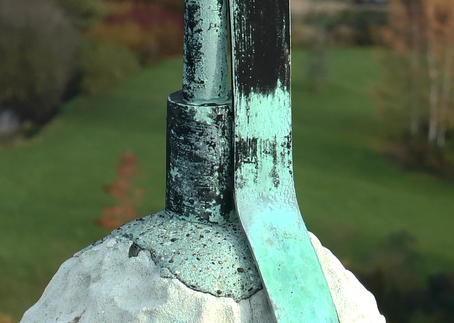 Any regular traveller on the East Coast main line or the A1 will be familiar with the dramatic sight of the spire of St. Peter’s Church, Yaxley, sitting on top of its hill, visible for many miles across the flat landscapes of the fens – even more so at night when it is floodlight, writes Peter Slinger RIBA, CA of Cambridge UAV. Early last year, I was invited to become the quinquenial architect for St. Peter’s and together with the Churchwardens, started planning for the forthcoming inspection.
As with most historic buildings of this date and complexity, access to some areas is difficult and potentially dangerous. The spire is surrounded by a parapet and flying buttresses which cannot be seen from ground level and which can only be accessed by a very narrow spiral stair as far as the ringing chamber and thereafter, ladders as far as the bell frame.
To reach the parapet from there, involves a very long vertical ladder up the centre of the spire and then a difficult and dangerous traverse from the ladder to the parapet door many metres above the ground. Not for the feint-hearted and an insurance nightmare. Consequently this element had not been inspected for very many years.
The solution came as a result of seeing UAV’s (commonly referred to as “Drones”) being used in other fields for high definition filming. Cambridge UAV agreed to help us with our inspection and the results were spectacular:
Cambridge Unmanned Aerial Vehicles
Aerial Visual Survey of difficult to reach and fragile structures – Alan Perrin
Cambridge Unmanned Aerial Vehicles (UAV) is a division of Cambridge Maintenance Service Ltd.
Cambridge Maintenance was founded in 1985 with its initial clients based on the prestigious Cambridge Science Park. Since then the Cambridge group of companies has expanded to incorporate specialist divisions needed to service a growing client base and now services national commercial contracts with prestigious buildings such asthe Hyde Park Estate.
Cambridge Maintenance had been operating various aerial platforms for many years to allow the visual inspection of high buildings and especially those that presented a challenge for access.
With the recruitment of staff that specialize in the field and the advent of reliable multi-rotor flight control systems and high capacity lithium polymer batteries it was decided to investigate the possibility of using unmanned aerial vehicles to fulfil some of the requirements of its survey and inspection work. After many months, suitable aircraft platforms had been designed and constructed and test flying could commence.
 As with many new technologies, a fair proportion of the development is determination and this proved to be so with the continuous progress of flight test and adjustment to arrive at the stable and reliable aircraft that are in use today.
The unmanned aircraft used by Cambridge are miniature marvels of technology.
Each aircraft carries a flight control system that has 3 gyros, 3 accelerometers, barometric pressure sensing and a 12 channel GPS system. There are two separate and completely independent radio control systems, one that controls the aircraft and a further system that has control of the camera gimbal. The gimbal itself is also packed with electronics that stabilize it and keep it looking where it’s pointed.
This sophisticated level of electronics allows the aircraft to be positioned by the pilot and held exactly in position and at the height needed regardless of most gusts of wind, letting the camera operator or surveyor concentrate on getting the visual inspection completed as quickly and efficiently as possible.
When contacted by a potential customer, the first element of our flight plan is to find out just exactly what you’re trying to achieve with the aerial survey. With ancient or ecclesiastical buildings, or fragile structures it’s normally a fixed structure that we’ll be flying near and the requirement is for HD video content in the survey. HD video can be paused and images extracted very easily for stills.
We are also able to provide images for land survey or plan views of plots for instance.
Once all risk assessments and safety checks have been carried out on the site, our Pilot will then discuss with the client the images they require and flight ops can begin.
Usually, during the flight, the images transmitted from the aircraft can be viewed by the client on the ground station screen, giving the ability to request any last minute adjustments.
Upon landing, the images can be reviewed and a copy supplied immediately.
Cambridge UAV have a team of licensed operators, after all, not just anyone can fly a UAV.
To be able to legally fly a UAV, the pilot has to have attended a flight ground school that teaches everything from air law through to risk assessment. Once the written exam is passed, the pilot is then required to take a flight test on the aircraft he will be using.
Any company wanting to fly a UAV commercially has to have a Permission for Aerial Work from the Civil Aviation Authority otherwise commercial use is illegal. Each aircraft is registered with the CAA and the pilot has to log his flying hours just like a full size aircraft.
Cambridge has a specific liability insurance to cover the aircraft whilst in flight, the payload it’s carrying and most importantly, any other third party.
Cambridge UAV are happy to discuss any projects that you may be involved in, we specialize in providing those impossible to get images of impossible to reach and fragile structures. More information can be found at www.cambridgeuav.co.uk
 Conclusion
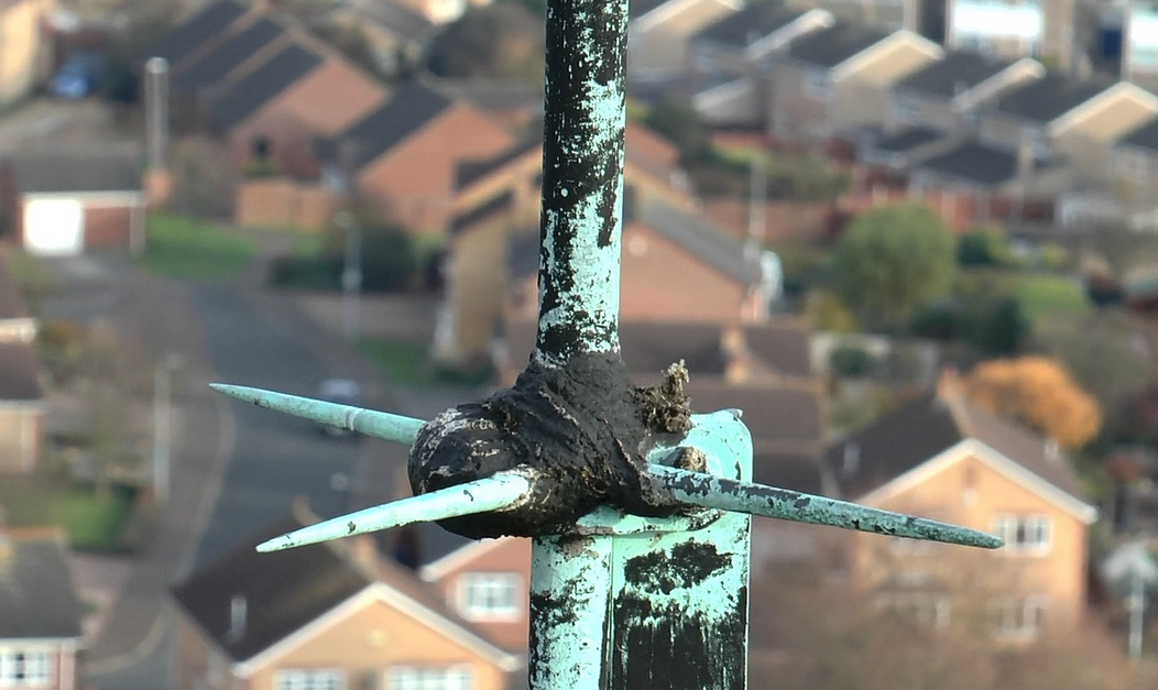
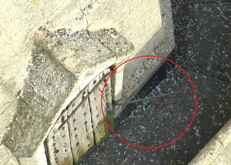
By working with Cambridge UAV, we obtained a very comprehensive understanding of the condition of parts of the church which were inaccessible and even discovered problems which would have been unlikely to have been noted even if we could have accessed them (for example the broken hinge to the spire door would have only been noted if we had got out onto the parapet and then closed the door behind us).
This is an invaluable tool, removing the need for time-consuming, costly and very dangerous access problems and providing high-definition records of otherwise inaccessible elements.
Peter Slinger
VISIT OUR ASSOCIATED SITES
![]()
![]()
![]()